One of my ongoing projects: imagining what Montreal's Metro system will look like in the future. Here's my fictitious 2032 Metro map, as released by the equally fictitious Societe de Transport du Quebec. (If you care to look at more fictitious future history, I collaborated on an article a couple months back about Montreal 2032, which you can read here.)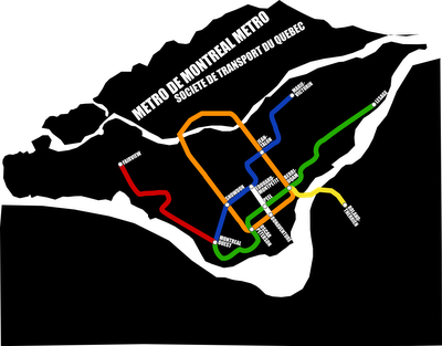

First I have to second the idea of the Fairview point, as a West-Islander myself, there is no bigger discouragement to have to go downtown knowing that it's gonna take minimum 1h30 unless you take the train.... 1h depending on the distance between you and the trainstation.Secondly, The white line covers a distance that can be done by foot, altough it is interesting to see that instead of going around downtown, you can simply go across... but will our wonderfull mayor accept to spend tax money for such a short distance?Great work!